Patio Engineering Drawings

Please leave your patio or carport details below and one of our representatives will be in touch to discuss your requirements.

Fully engineered by industry professionals to BCA standards.

Our patio engineering standards cover the below details.

  • Engineering for gable, flat, skillion, curved and hip end patios and carports.
  • Allowances for on-concrete and in-concrete construction.
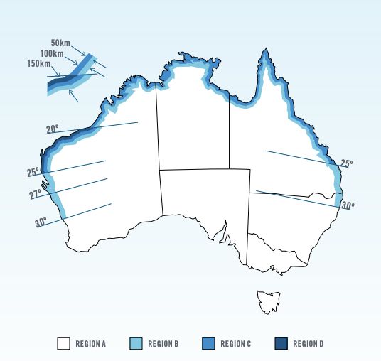
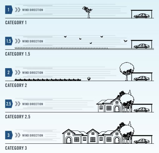
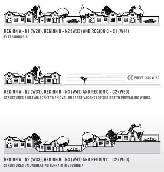
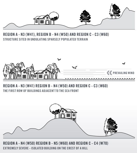
  • Region A-D and Wind Speed N1-C4.
  • Freestanding patios.
  • Patios up to 3.6m high.
  • Gr350 and Gr450 steel tube.
  • Utilises readily available steel sizes including but not limited to 76×38, 100×50, 150×50, 100×150, 90×90.
  • Compatible with Colorbond sheeting, insulated sheeting and cedar lining.
  • Can be used with our masonry wall engineering standards for on the boundary construction.
  • Easy to understand connection details with all tek screwed connections.

Custom Engineering Solutions

If your patio does not fit our standard specifications it is not a problem. We can design and engineer a solution specific for your job.

Please fill in the form below and one of our representatives will be in touch to discuss your project.

Enquire about standard or custom patio engineering

  • Drop files here or
    Accepted file types: jpg, gif, png, pdf, Max. file size: 50 MB, Max. files: 6.

    Wind Speed Classification

    Before erecting a patio, particularly in coastal regions in Northern Australia it is important to consider a range of factors: Region (Figure 1.0), Terrain Category (Figure 2.0), Shielding Factor (Figure 4.0), and Topographic Classification (Table 2.0).

    For permissible gust wind speed refer to table (1.0).

    This considers these four variables in accordance with the Australian Standard AS/NZS1170.2:2011.

    Patio wind speed classification
    Wind ClassificationGust Wind Speed
    meters per second
    Regions A & BRegions C & D
    N1 (Non-Cyclonic)N/AW28
    N2 (Non-Cyclonic)N/AW33
    N3 (Non-Cyclonic)C1 (Cyclonic)W41
    N4 (Non-Cyclonic)C2 (Cyclonic)W50
    N5 (Non-Cyclonic)C3 (Cyclonic)W60
    N6 (Non-Cyclonic)C4 (Cyclonic)W70
    Wind speed regions
    Figure 1.0
    Topographic Classification
    RegionTerrain CategoryT0T1T2T3
    FSPSNSFSPSNSFSPSNSFSPSNS
    A1N2N3N3N3N3N3N3N4N4N3N4N4
    1.5N2N2N3N2N3N3N3N3N4N3N4N4
    2N1N2N2N2N3N3N2N3N3N3N3N4
    2.5N1N2N2N2N2N3N2N3N3N3N3N3
    3N1N1N2N1N2N2N2N3N3N2N3N3
    B1N3N4N4N4N4N5N4N5N5N5N5N5
    1.5N3N4N4N3N4N4N4N4N5N4N5N5
    2N3N3N3N3N4N4N4N4N4N4N4N5
    2.5N3N3N3N3N3N4N3N4N4N4N4N5
    3N2N3N3N3N3N3N3N4N4N3N4N4
    C1C2C3C3C3C3C4C3C4C4C4C4N/A
    1.5C2C3C3C2C3C3C3C3C4C3C4C4
    2C2C2C2C2C3C3C3C3C3C3C3C4
    2.5C1C2C2C2C2C3C2C3C3C3C3N3
    3C1C2C2C2C2C2C2C3C3C2C3C3
    D1C4C4N/AC4N/AN/AN/AN/AN/AN/AN/AN/A
    1.5C3C4C4C4C4N/AC4N/AN/AN/AN/AN/A
    2C3C3C4C3C4C4C4N/AN/AC4N/AN/A
    2.5C3C3C3C3C4C4C4C4N/AC4N/AN/A
    3C2C3C3C3C3C4C3C4C4C4C4N/A

    The windspeed impact upon a structure is further influenced by the terrain it flows over. Sparsely populated, clear land provides less wind resistance than undulating land with a greater density of trees and structures.

    Category 1 Terrain which is open with few obstructions (trees or man made structures); may include enclosed water surfaces, flat, treeless and poorly grassed plains, rivers or lakes with no buildings, or enclosed bays less than 10km in the wind direction.

    Category 1.5 Larger open water surfaces including coastal waters, large open bays on seas, oceans or lakes, and enclosed bays less than 10km in the wind direction.

    Category 2 Open terrain, including grasslands with fewer than two obstructions (1.5 to 5m high) per hectare.

    Category 2.5 Terrain with isolated obstructions such as outer urban areas with scattered houses and few trees.

    Category 3 Terrain covered with numerous obstructions that are closely spaced, with heights between 3 and 10m. For example suburban housing.

    Wind speed terrain category
    Figure 2.0

    The windspeed impact upon a structure is further influenced by the terrain it flows over. Sparsely populated, clear land provides less wind resistance than undulating land with a greater density of trees and structures.

    Category 1 Terrain which is open with few obstructions (trees or man made structures); may include enclosed water surfaces, flat, treeless and poorly grassed plains, rivers or lakes with no buildings, or enclosed bays less than 10km in the wind direction.

    Category 1.5 Larger open water surfaces including coastal waters, large open bays on seas, oceans or lakes, and enclosed bays less than 10km in the wind direction.

    Category 2 Open terrain, including grasslands with fewer than two obstructions (1.5 to 5m high) per hectare.

    Category 2.5 Terrain with isolated obstructions such as outer urban areas with scattered houses and few trees.

    Category 3 Terrain covered with numerous obstructions that are closely spaced, with heights between 3 and 10m. For example suburban housing.

    Wind speed topographic effect
    Figure 2.0
    Note: Diagrams are applicable for hills up to 30m in height. Refer to AS4055-2011 for heights exceeding 30m.
    Wind speeds have been determined using the following factors, in accordance with AS/NZS1170.2:2011 500 year design return period and an average five metre structure height.
    Note: A 5% allowance has been used when allocating the wind classification

    Terrain Categories (MZ,cat)

    Terrain CategoryRegions A, B, C, & D
    11.05
    1.50.98
    20.91
    2.50.87
    30.83

    Shielding Factor (MS)

    Shielding ClassificationsFactor
    Full Shielding (FS)0.85
    Partial Shielding (PS)0.95
    No Shielding (NS)1.00

    Topographic Effect (MT)

    Topographic ClassificationsFactor
    T01.00
    T11.10
    T21.20
    T31.30

    Direction Multiplier (MD)
    In all cases a factor of 1.00

    The examples below show typical applications of the rationalised gust wind speeds. For a full analysis refer to AS/NZS1170.2:2011.
    Wind speed examples
    Wind speed examples 2

    Disclaimer

    Please Note: This document is provided as a design guide only. The information provided here is written in compliance with the requirements of AS/NZS1170.2:2011 and is classified in accordance with wind classifications allocated in AS4055:2012. Patio Engineering Australia does not accept any liability for any loss or damage that results from the misinterpretation of this design guide. When uncertain it is recommended to seek the advice of an independent engineer.